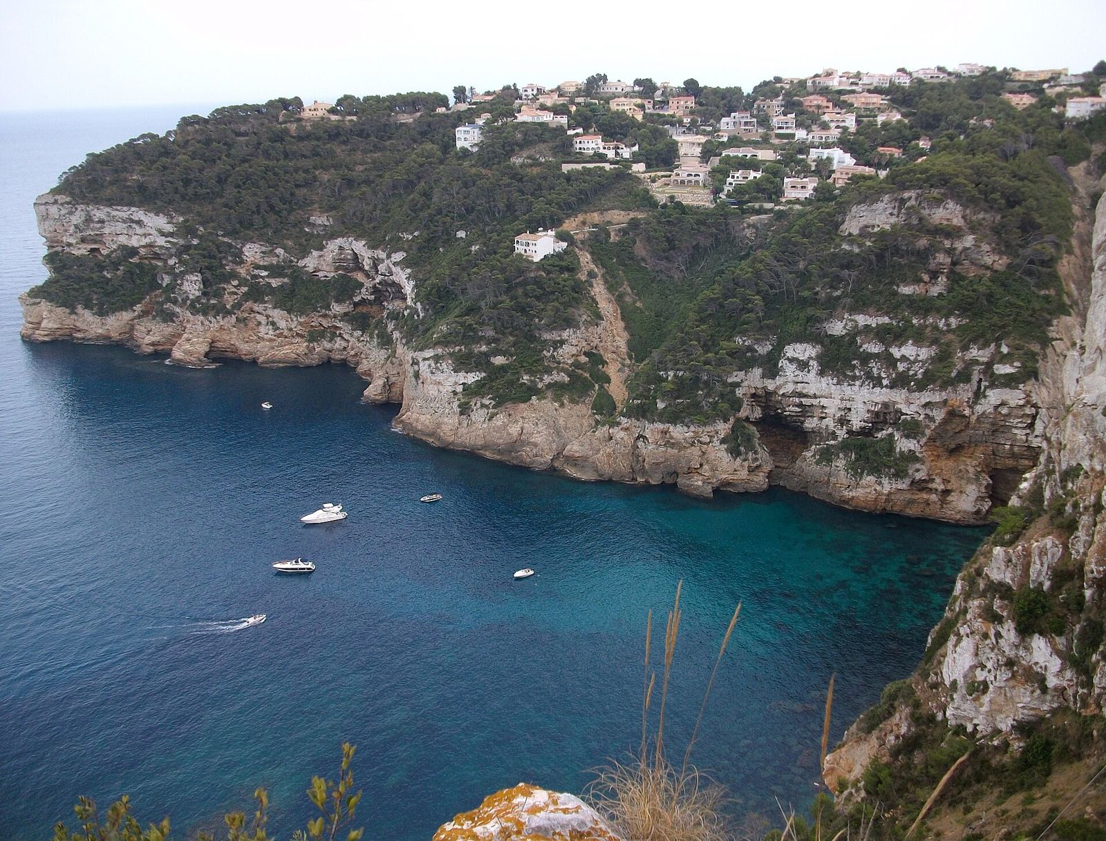
Cap Negre is a pine-covered rocky headland on Jávea's southern coast, between Portitxol and the Cap de la Nau, with villas set among the trees and views over the sea.
Where is Cap Negre?
On the coast south of Portitxol, before the Cap de la Nau.
The pin marks the approximate centre of Cap Negre. Map data © OpenStreetMap contributors.
What is Cap Negre like?
Pine woodland, rocky shoreline and low-density villas.
A little history
Cap Negre is one of Jávea's four capes. From its viewpoint you can see almost the whole coast of Jávea: Cap Prim, the Cap de Sant Antoni, the Montgó and the Portitxol island, and the old paths fishermen used to climb down to the sea are still visible on the cliffs.
Just beyond it is the Cap de la Nau, the easternmost point of the Valencian region. Its lighthouse, about 122 metres above the sea, came into service in 1928, and below it is the Cova dels Orguens, a sea cave described by the botanist Cavanilles in the late 18th century, now a kayak and boat destination.
Getting around Cap Negre
By car only; roads are winding.
Beaches and coves near Cap Negre
The nearest beaches and coves to Cap Negre, measured in a straight line from the centre of the area:
- The Portitxol (La Barraca) cove (about 1.4 km away): a pebble cove facing Portitxol island; the access road is closed with a barrier when the car park fills in summer, and there is a footpath down from the Creu del Portitxol.
- Cala Sardinera (about 2.0 km away): a small cove near Cap Prim.
- Cala d'Ambolo (about 2.1 km away): a cove that is officially closed to the public because of the risk of rockfalls from the cliffs.
Things to see near Cap Negre
Worth knowing about if you live in or visit Cap Negre:
- The Cap Negre and Falzia viewpoints, about 100 m away: two clifftop viewpoints from which you can see almost the whole Jávea coastline, from Cap Prim to the Cap de Sant Antoni.
- The Cap de la Nau lighthouse, about 1.5 km away: the lighthouse and viewpoint on Jávea's eastern tip; on clear days the view reaches Moraira, the Peñón de Ifach and Ibiza.
- The Creu del Portitxol, about 1.7 km away: a viewpoint with a cross looking straight out to Portitxol island.
Everyday essentials
The nearest large supermarkets are ALDI (about 3.7 km), Consum (about 4.2 km) and Masymas (about 4.6 km). The closest public health centre is the Duanes de la Mar health centre at the Port, about 7 km away. Closer still, the auxiliary clinic on the Avenida de París in the Arenal opens at Easter and in summer only. The nearest state primary school is CEIP l'Arenal, about 4.8 km away; school places are allocated through the regional admissions process, not by distance alone. For hospital care, Jávea is covered by the Hospital de Dénia.
How far is Cap Negre from…
| Place | Straight-line distance |
|---|---|
| The Old Town (Plaça de l'Església) | about 8 km |
| The Port | about 7 km |
| The Arenal beach | about 4.7 km |
| Club de Golf Jávea | about 7 km |
| Hospital de Dénia | about 18 km |
Distances are measured in a straight line from the approximate centre of Cap Negre; by road they are longer, especially from the hillside urbanisations.
What do homes in Cap Negre usually need?
- Pine woodland brings processionary caterpillars and fire-safety clearing; see tree surgeons and our caterpillar guide.
- Pine needles block gutters before storms; see the gota fría guide.
What is on the ground in Cap Negre
OpenStreetMap shows no shops, bars or restaurants within about 700 metres of the centre of Cap Negre: it is purely residential, so everyday shopping means a drive.
Like neighbouring Balcón al Mar, its streets are named after composers: Haydn, Mahler, Monteverdi, Mendelssohn.
Counts from OpenStreetMap, which volunteers keep up to date; small or new places may be missing.
Businesses based in and around Cap Negre
Going by their Google Maps pins, 2 of the businesses on Javea1 are based within about 1.3 km of the centre of Cap Negre, across 1 trades. Most trades also travel to you wherever you live in Jávea.
Show the businesses near Cap Negre, by trade
Nearest everyday services to Cap Negre
The closest business of each kind on Javea1 to the centre of Cap Negre, measured in a straight line from its Google Maps pin:
| Service | Nearest | Distance |
|---|---|---|
| Pharmacy | Farmacia Cholbi Mulet | 3.1 km |
| Doctor or private clinic | Point of Care | 3.9 km |
| Dentist | Accu Dental | 4.7 km |
| Vet | Centro Veterinario M Carmen García | 4.7 km |
| Hardware shop | Ferretería Pla 48 | 4.2 km |
| Mechanic | Motos Ruta 22 | 1.5 km |
| Bank | CaixaBank Store | 4.5 km |
| Optician | Óptica Dalia Jávea | 4.8 km |
| Physiotherapist | Fisioterapia a domicilio Javea | 4.6 km |
| Hairdresser | Peluquería Jávea - Art en Tall | 4.4 km |
| Pet shop | Animals | 5.1 km |
| Laundry or dry cleaner | Open Blue Javea | 4.5 km |
Where to eat near Cap Negre
See restaurants in the coves from Cap Martí to Granadella, with Google ratings and map links, or browse all restaurants in Jávea and our guide to eating out in Jávea.
Local services for Cap Negre
Quick answers
Where is Cap Negre in Jávea?
On the coast south of Portitxol, before the Cap de la Nau.
Do I need a car in Cap Negre?
By car only; roads are winding.
What is the nearest beach to Cap Negre?
The Portitxol (La Barraca) cove, about 1.4 km away in a straight line: a pebble cove facing Portitxol island; the access road is closed with a barrier when the car park fills in summer, and there is a footpath down from the Creu del Portitxol.
Which businesses are based in Cap Negre?
Javea1 lists 2 businesses within about 1.3 km of the centre of Cap Negre, across 1 trades, including Soluna Beach, Bar La Barraca.