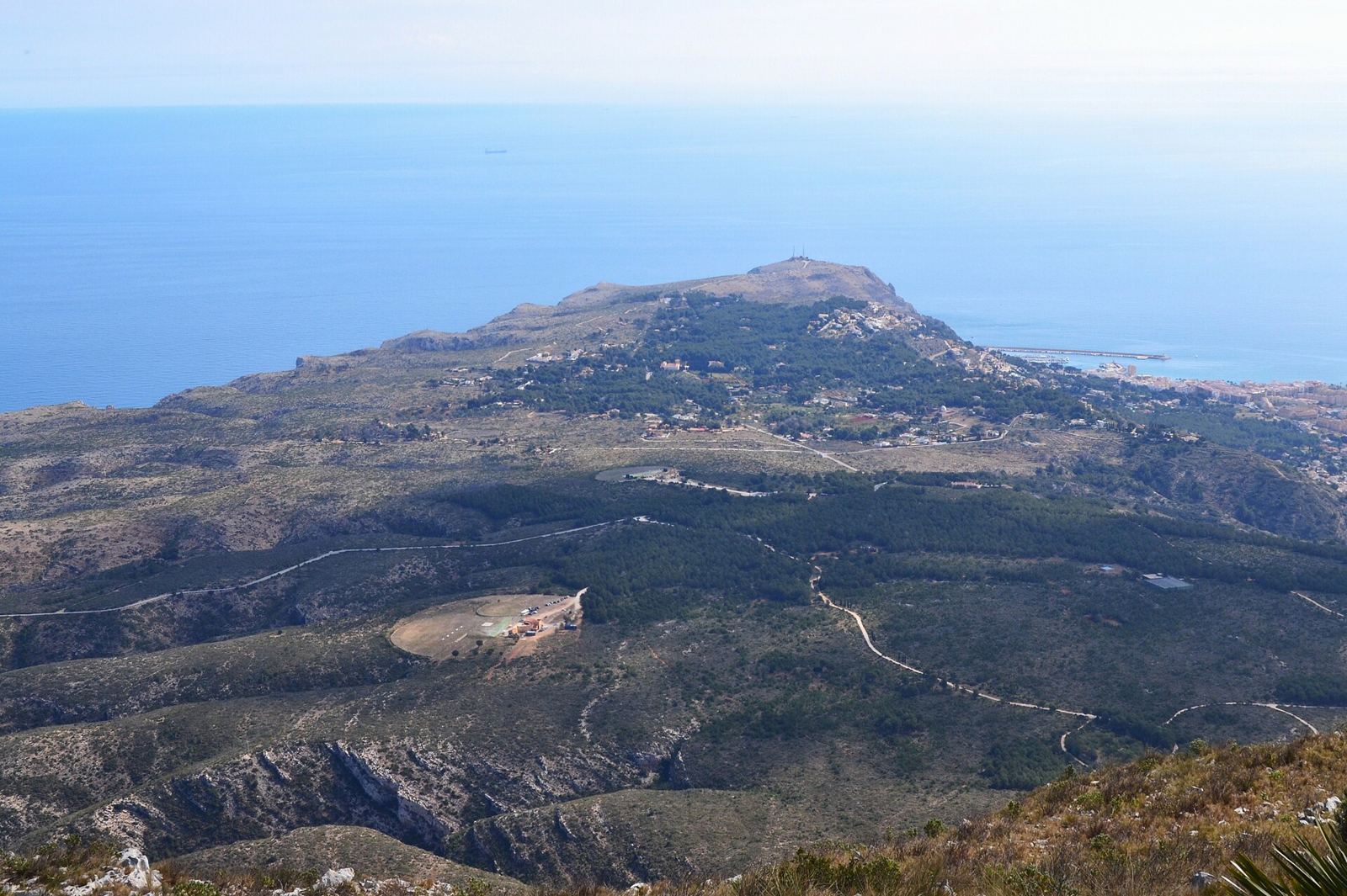
La Plana, or Les Planes, is the plateau between the Montgó and the Cap de Sant Antoni, where the mountain slopes down to the sea. Reached from the Jávea to Dénia road, it is a quiet, green area of villas on large plots, much of it close to the natural park and the lighthouse.
Where is La Plana?
North of the Port, between the Montgó to the west, the sea cliffs to the north and the Cap de Sant Antoni lighthouse to the east.
The pin marks the approximate centre of La Plana. Map data © OpenStreetMap contributors.
What is La Plana like?
Open and natural, with villas on large plots among pines and old terraces; the road to the cape is its main street.
A little history
Les Planes is the plateau between the Montgó and the Cap de Sant Antoni, and it is inside the Montgó Natural Park. Along its southern edge stands a line of eleven windmills, the most important group of flour mills in the Valencian region, built between the 14th and 18th centuries to grind wheat with the south-westerly llebeig wind; Jávea town hall now owns several of them.
At the cape, the lighthouse viewpoint is about 161 metres above the sea, and on clear days Ibiza is visible. The sea below has been a marine reserve since 1993, and the town hall has a project to turn the lighthouse into an interpretation centre for the reserve.
Getting around La Plana
Car-based: take the Jávea to Dénia road and turn off towards the Cap de Sant Antoni. The Port is a few minutes' drive down the hill.
Beaches and coves near La Plana
For a swim, the nearest spots to La Plana are:
- La Grava (about 2.5 km away): the beach at the Port, next to the promenade, with lifeguards in the summer season.
- Benissero (Primer Muntanyar) (about 3.1 km away): a pebble beach that is popular with residents because it gets less crowded, with lifeguards in high season.
- The Segon Muntanyar (about 3.9 km away): a stretch of flat rocks and small coves used for swimming and snorkelling.
Things to see near La Plana
Places to see within easy reach of La Plana:
- The windmills of La Plana (Els Molins), about 700 m away: a row of eleven old windmills on La Plana, most built in the 18th century, which is now one of the stops on Jávea's viewpoint route.
- The Ermita de Santa Llúcia, about 1.9 km away: a 17th-century hermitage on a 163-metre hill above the Old Town, with views over the valley and the bay.
- The municipal market, about 2.2 km away: the covered market in the Old Town, a 1946 building in a style inspired by civic Gothic.
Everyday essentials
The nearest large supermarkets are Masymas (about 2.3 km), Mercadona (about 2.3 km) and Lidl (about 2.4 km). The closest public health centre is the Duanes de la Mar health centre at the Port, about 2.2 km away. The nearest state primary school is CEIP Port de Xàbia, about 2.3 km away; school places are allocated through the regional admissions process, not by distance alone. For hospital care, Jávea is covered by the Hospital de Dénia.
How far is La Plana from…
| Place | Straight-line distance |
|---|---|
| The Old Town (Plaça de l'Església) | about 2.2 km |
| The Port | about 2.5 km |
| The Arenal beach | about 4.7 km |
| Club de Golf Jávea | about 7 km |
| Hospital de Dénia | about 9 km |
Distances are measured in a straight line from the approximate centre of La Plana; by road they are longer, especially from the hillside urbanisations.
What do homes in La Plana usually need?
- Homes next to protected land face extra rules on building, walls and clearing; see building permits.
- Large wooded plots need firebreak clearing and tree work; see tree surgeons and gardeners.
- Exposed, higher ground takes the wind; check roofs and awnings before winter: see roofers.
What is on the ground in La Plana
Within about 1000 metres of the centre of La Plana, OpenStreetMap shows 2 places to eat or drink and 1 playground.
Street names you will see around La Plana include Carretera del Cap de Sant Antoni, Camí dels Molins, Camí Creuat and Camí Curt.
Counts from OpenStreetMap, which volunteers keep up to date; small or new places may be missing.
Businesses based in and around La Plana
Going by their Google Maps pins, 4 of the businesses on Javea1 are based within about 1.3 km of the centre of La Plana, across 3 trades. Most trades also travel to you wherever you live in Jávea.
Show the businesses near La Plana, by trade
Nearest everyday services to La Plana
The closest business of each kind on Javea1 to the centre of La Plana, measured in a straight line from its Google Maps pin:
| Service | Nearest | Distance |
|---|---|---|
| Pharmacy | Farmacia Optica Amparo Marsal | 2.0 km |
| Doctor or private clinic | Centro de Salud Xàbia Duanes de la Mar | 2.2 km |
| Dentist | Clinica Dental El Puerto | 2.0 km |
| Vet | Centro Veterinario Albeitar | 2.2 km |
| Hardware shop | BricoThiviers - Ferretería y bricolaje | 2.1 km |
| Mechanic | Talleres Avenida | 2.0 km |
| Bank | Cajamar Caja Rural | 2.1 km |
| Optician | Óptica Robin Look Xàbia | 2.1 km |
| Physiotherapist | Alejandro Martínez Fisioterapia | 2.2 km |
| Hairdresser | Yolanda Olivares Estilistas | 2.2 km |
| Pet shop | Mihapi | 2.2 km |
| Laundry or dry cleaner | Lacolada | 2.1 km |
Local services for La Plana
Quick answers
Where is La Plana in Jávea?
North of the Port, between the Montgó to the west, the sea cliffs to the north and the Cap de Sant Antoni lighthouse to the east.
Do I need a car in La Plana?
Car-based: take the Jávea to Dénia road and turn off towards the Cap de Sant Antoni. The Port is a few minutes' drive down the hill.
What is the nearest beach to La Plana?
La Grava, about 2.5 km away in a straight line: the beach at the Port, next to the promenade, with lifeguards in the summer season.
Which businesses are based in La Plana?
Javea1 lists 4 businesses within about 1.3 km of the centre of La Plana, across 3 trades, including Kayak Javea, K9 Clip and Cut, Xàbia Activa.